Cable railway – Mt. Mitake – Ayahiro Falls – Mt. Hinode – Cable railway
Introduction
Mt. Mitake(御岳山), located in the west of Tokyo, is a popular mountain for Tokyo and Kanto region people. The elevation is not so high, and there is a cable car, so you can easily go up the mountain.
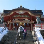
On the top of the mountain, there is the Musashi Mitake Shrine (武蔵御嶽神社). Many mountain ascetics and worshipers have visited this sacred mountain since hundreds of years ago. Today the shrine is also famous for the god of dogs.
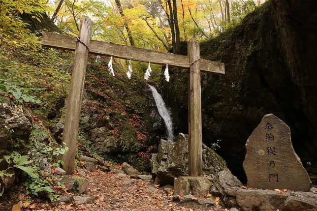
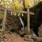
On the back side of the mountain, there are popular hiking trails where you can see beautiful waterfalls and valleys. At the Ayahiro Falls (綾広の滝), you can experience traditional waterfall meditation called Takigyo (滝行). For more details about Takigyo, please check this website: Mountains and Mediations
About Mt. Mitake
- Elevation : 929 m
- Location : Western Tokyo (Okutama area)
- Belongs to Chichibu Mountains, Chichibu-Tama-Kai National Park
- Non-volcanic
Season
Best Season : May, Oct. – Dec.
| Jan. – Apr. | Cold, sometimes snowfall |
| May.- June | Warm, Fresh green |
| July – Sept. | Very hot and humid |
| Oct. – Dec. | Cool, Autumn leaves |
| Nov. | Cold |
Route Map & Guide
Mt. Mitake Main Route
This route is the route from the cable railway station to the summit of Mt. Mitake. Most of this route is on a well-maintained concrete road and easy to walk.
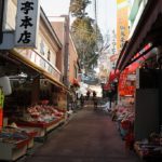
On the way to Mt. Mitake, you will pass through a small village with many traditional guest houses, japanese restaurants and souvenir shops.
The road leads to a long stairway at the end. On the end of stairway, there is the Musashi Mitake Shrine and the summit of Mt. Mitake is in the premises of the shrine.
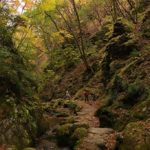
Trail of Falls and Rocks
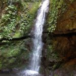
This trail is along the stream on the opposite slope of the mountain. There are two waterfalls, Ayahiro Falls (綾広の滝) and Nanayo Falls (七代の滝). Both waterfalls are not big but beautiful and sacred. The area between these two falls are called “Rock Garden”. Various shapes of rocks make beautiful scenery of the valley. Since there are steep slopes and ladders, so please walk carefully.
Mt. Mitake – Mt. Hinode
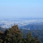
Mt. Hinode (日の出山) is a mountain located next to Mt. Mitake. The Japanese word “Hinode” means sunrise. As the name suggests, you can see nice view of the east side from the summit of the mountain. On a clear day, you can see skyscrapers in central Tokyo.
One hour walking on the trail on ridgelines lead to Mt. Hinode. The most part of the trail is flat. So it’s not so hard.
Course Time
| Mitake-san Station (Cable railway) <–> Mt. Mitake | 30 mins |
| Trail of Falls and Rocks Mt. Mitake <–> Nanayo Fall <–> Ayahiro Falls <–> Mt. Mitake |
2 hours |
| Mt. Mitake <–> Mt. Hinode | 1 hour |
*The course time is one way-time.
Example Plan
Normal Plan
Mitake-san Station –> Mt. Mitake –> Nanayo Fall –> Ayahiro Fall –> Mt. Mitake –> Mt. Hinode –> Mitake-san Station
Takigyo Plan (2-Day)
Add 1 day and stay the Komadori Sanso lodge (駒鳥山荘), you can experience the Takigyo next day.
1st day: Same as the normal plan
2nd day: Experience Takigyo
Access
From Tokyo
- JR Tokyo Sta. [東京駅] or Shinjuku Sta.[新宿駅] ==> Tachikawa Sta. [立川駅]
Chuo Line (Rapid, Special Rapid, Holiday Rapid), - Tachikawa Sta. [立川駅] ==> Ome Sta. [青梅駅]
Ome Line - Ome Sta. [青梅駅] ==> Mitake Sta. [御嶽駅]
Ome Line - Mitake Sta.[御嶽駅] bus stop ==> Keburu-shita[ケーブル下] bus stop
Nishi-tokyo Bus route [御10] or [御11] bound for Keburu-shita
2 buses per hour.
If use “Holiday Rapid Okutama”[ホリデー快速おくたま] train which runs on holidays, you can go from Tokyo or Shinjuku to Mitake Sta. without transfer.